Start Here
Wayfinding signage is a comprehensive system of visual cues that guides visitors through complex environments like airports, malls, hospitals, and campuses. Effective wayfinding signage enhances the visitor experience by providing clear identification, directional, informational, and regulatory cues, while modern digital solutions add dynamic routing, real-time updates, accessibility features, and monetization opportunities. Best practices include consistent naming, accessible design, multi-modal guidance, and centralized management through robust CMS platforms. Choosing the right wayfinding partner involves evaluating mapping quality, integration capabilities, analytics, and support. Mappedin stands out as a leader, offering interactive directories, centralized map management, seamless integrations, and proven results in improving navigation, visitor satisfaction, and operational efficiency for venues worldwide.
From massive airports to complex healthcare system campuses, wayfinding signage is essential to smooth, stress-free visitor experiences.
The most effective wayfinding signage is intuitive, clear and up to date; it helps people navigate complex spaces by providing clear identification, directional, informational, and regulatory cues. Modern wayfinding signage systems blend static signs with digital directories, interactive indoor maps, and mobile handoffs to deliver fast, accessible routes for every visitor.
In this guide, you’ll learn the fundamentals of signage and wayfinding, how digital signage enhances wayfinding, interior wayfinding best practices, how to evaluate wayfinding signage companies, and how to measure ROI.
Let’s dive in.
What is wayfinding signage?
Wayfinding signage is the system of visual cues—signs, maps, symbols, and digital interfaces—that guide people through a physical environment. It helps visitors answer four core questions:
- Where am I?
- Where is my destination?
- How do I get there?
- What should I do next?

Signage and wayfinding: How signage enhances visitor experience
While interconnected, signage and wayfinding are separate concepts. Signage is the tangible, individual artifacts that aid in visitor navigation and experience, like room ID signs, directional arrows, regulatory notices and directories. Signage could be either physical, such as a permanent sign, or digital, such as a digital, interactive kiosk.
Wayfinding, on the other hand, is the holistic strategy that organizes information, signage, maps, and technology to enable intuitive navigation across the entire journey. Wayfinding is a key factor in stress-free, enjoyable visitor experiences.
A strong wayfinding program aligns both, so every sign or screen serves a clear role within a coherent system.

Core functions of wayfinding signage
Wayfinding signage serves multiple important functions in a visitor journey, and—equally important—for venue administration.
Let’s review each function:
Identification: Signage provides labels for spaces that a visitor might navigate to, in order to confirm arrival. This could be rooms, airline gates, restrooms, stores—any place within the venue that see visitor foot traffic.
Directional: Wayfinding signage can aid in visitor navigation by pointing to destinations with arrows and distance/time indicators. A lost visitor is often a stressed out visitor, so this signage is critical to improving guest/passenger/patient experience.
Informational: Signage provides context to the places they may visit during their experience, like listing store hours, popular amenities, or upcoming events.
Regulatory: Signage communicates required behaviors within the venue for guests to keep in mind, such as safety precautions, accessibility notices, or compliance. This type of signage could be important for venues staying compliant with regulatory requirements.
Interior wayfinding vs. outdoor wayfinding
Wayfinding can be applied to both indoor and outdoor spaces, or venues that include both, like a multi-use venue. Interior wayfinding focuses on navigation within buildings and multi-building campuses where GPS is limited or unavailable. It relies on consistent naming, floor transitions, and venue maps.
Outdoor wayfinding, on the other hand, covers streetscapes, parks, and districts, often integrating landmarks, pedestrian paths, and transit nodes. Both indoor and outdoor wayfinding benefit from wayfinding signage.
Accessibility-first wayfinding
An accessible venue is an inclusive one. Accessibility in wayfinding improves outcomes for everyone, regardless of ability or age. Signage plays a key role in accessibility-first wayfinding.
- Prioritize these things for accessibility-first wayfinding:
- ADA- and WCAG-informed design (contrast ratios, legible typography, color-blind-friendly palettes).
- Tactile and braille elements where appropriate.
- Step-free, wheelchair-accessible routing and clear elevator/escalator wayfinding.
- Audio and multi-language support on digital interfaces.
How can wayfinding enhance navigation?
In short, digital signage makes wayfinding dynamic, interactive, and measurable. It complements static signs by offering search, personalized routes, real-time updates, and the ability to monetize idle screen time.
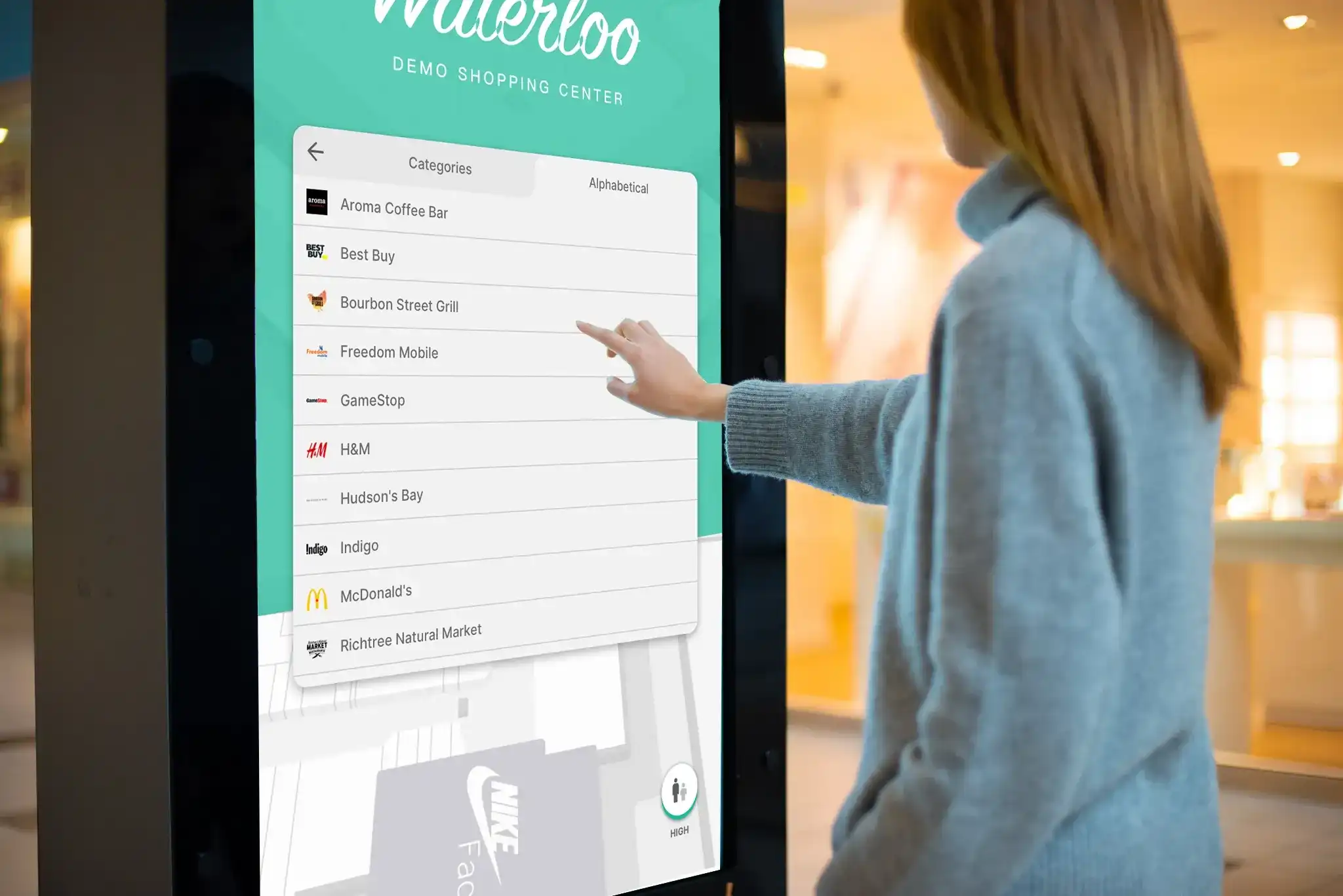
Interactive directories and kiosks
Interactive wayfinding signage like digital directories and kiosks can aid visitors in finding what they need, when they need it.
For example, visitors can:
- Search by name, category, or “near me.”
- Use one-tap routing to key amenities (restrooms, exits, security).
- Get “You are here” context with a clear starting point and orientation.
- Use nearest-path logic that factors in accessibility preferences.

Map-powered guidance
Digital indoor maps, like the ones powered by Mappedin, facilitate smooth visitor wayfinding by providing step-by-step routes that display turn-by-turn directions and estimated time to destination, “blue dot” positioning to identify precise user location within the venue, and live density or closure information. Map-powered guidance goes a step beyond digital wayfinding signage to power data-backed visitor experiences.
Real-time updates and dynamic messaging
Some wayfinding signage tools let you integrate with other venue systems to serve up holistic and cohesive visitor experiences with the information they need, all in one place:
- Sync with event feeds, tenant updates, closures, and emergency alerts.
- Dynamically re-route around maintenance or pop-up queues.
- Target content by time of day, venue zone, or audience segment.
Monetization via digital out-of-home (DOOH) on idle or engagement states
Venues can use digital signage to drive revenue opportunities, like:
- Showcase promotions, sponsor messages, and campaigns in idle state.
- Trigger context-aware ads (e.g., coffee offer en route to a morning meeting).
- Track impressions, dwell time, and clickthroughs where applicable.
Mappedin's Directory Ads feature enables monetization of digital directory screens through DOOH advertising with two placement options: full-screen overlays and homepage banners that display during idle use or visitor interactions.
Wayfinding signage types & technology: Which to choose based on venue needs
Modern wayfinding combines both physical signage with digital systems and data. Together, they produce a streamlined, easy-to-navigate visitor experience that provides guests with the information they need, right at the point of inspiration. Let’s explore the different signage options and what each can offer.
Static signage
Static signage is the most traditional type of wayfinding signage. It encompasses identification, directional, and regulatory elements that orient and instruct visitors without relying on power or connectivity.
Identification signs label rooms, gates, and tenants to confirm arrival, while directional signage appears before decision points to point toward destinations with clear arrows and distances. Regulatory signage communicates safety rules and code-required notices, including evacuation routes, to keep visitors compliant and informed. Static signage is a necessary element of any large and complex venue – it keeps visitors informed, on track and en route.
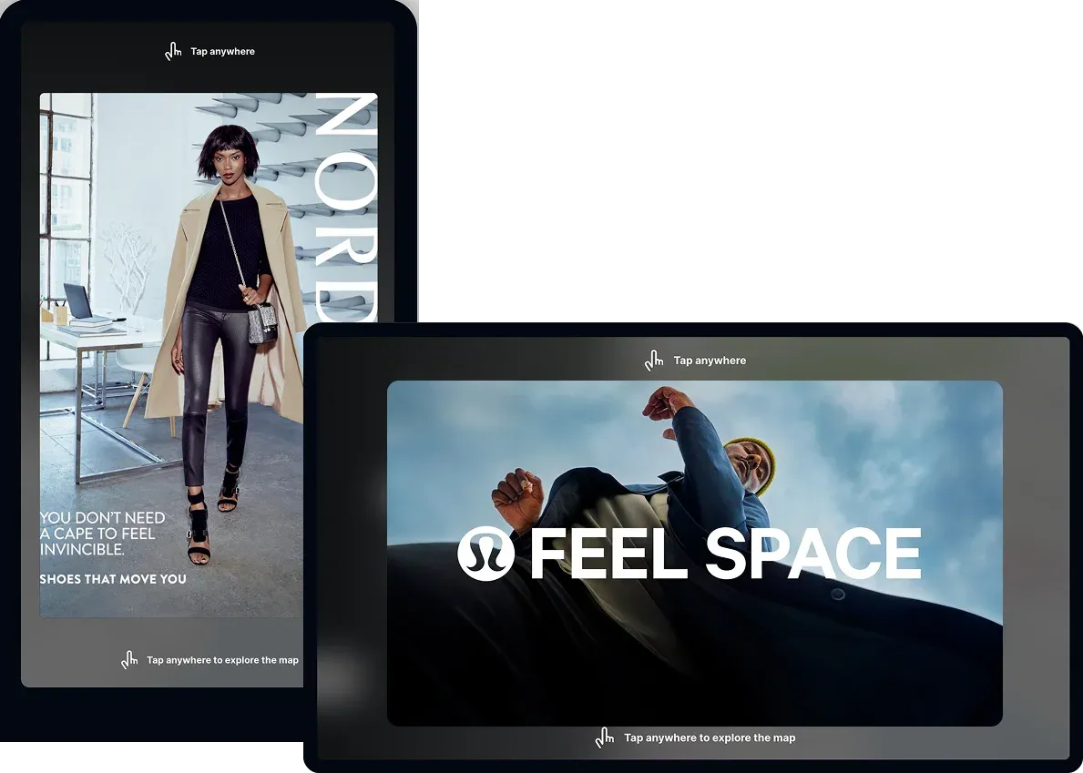
Digital signage and directories
Digital signage and directories typically use LCD/LED screens, kiosks, and video walls to present live information and intuitive maps at key decision points.
Touch-enabled interfaces let visitors search by name or category and instantly preview the fastest or most accessible route. Scheduling and dayparting ensures venues that layouts and messages adapt to the time of day, audience, and events. Digital signage is key to creating stress-free, revenue-generating visitor experiences, keeping guests informed and driving marketing initiatives.
Indoor mapping and location technology
Indoor mapping models levels, units, points of interest, and pathways to produce accurate, multi-level routes that reflect real visitor movement. Positioning—the method to determine the accurate and precise location of the visitor—can be powered by BLE beacons, Wi‑Fi RTT, camera-based systems, or sensor fusion to enable blue‑dot experiences where appropriate. A robust CMS manages map data and content at scale, while SDKs and APIs make it easy to integrate wayfinding into web, mobile, and partner platforms.
Mappedin’s CMS allows venues to edit venue maps and maintain real-time location information all in one place, powering accurate and interactive mapping experiences for complex venues around the world.
Mobile wayfinding and QR codes
Kiosk information and display doesn’t have to be limited to one static location within your venue.
Mobile wayfinding can mirror kiosk functionality on a visitor’s phone so they can continue navigation after stepping away from a screen.
QR codes can be used at venues to bring this navigation assistant to any visitor’s device, with a single click. QR code technology enables a seamless handoff from a directory to a web or app experience, preserving the destination and preferences like accessible routing. Venues can also trigger timely notifications tied to appointments, events, or proximity-based updates.
10 best practices of interior wayfinding signage
The best interior wayfinding and signage minimizes friction at decision points and shortens time-to-destination. From design to data, follow these best practices when implementing wayfinding signage:
1. Establish a clear information hierarchy and naming system
Standardize floors, zones, landmarks, and destination names across signage, maps, and apps to eliminate ambiguity. Keep taxonomy shallow and consistent to speed recognition.
2. Place signs at decision points with optimized sightlines
Position directional signage before intersections, elevators, and escalators so choices are obvious. Ensure visibility from common approach angles and distances.
3. Use a consistent design system, including icons, typography and color
Adopt a unified set of symbols and legible type, and reserve color for functional meaning (e.g., emergency routes). Maintain high contrast for readability in real-world lighting.
4. Design for accessibility by default
Provide step-free routing, clear elevator/escalator cues, tactile and braille where required, and WCAG-aligned digital interfaces. Make accessible routes the default or a one-tap option on directories.
5. Provide multi-modal guidance with mobile handoff
Combine static confirmation signs with interactive directories for discovery and routing. Enable QR codes so visitors can continue navigation on their phones without re-entering destinations.
6. Orient users with "You are here" maps that match facing direction
Align maps to the user’s real-world orientation to reduce cognitive load and wrong turns. Include clear floor-switch indicators for multi-level routes.
7. Use multilingual and plain-language labels
Translate essential wayfinding information based on visitor demographics and rely on globally recognized symbols. Keep copy concise, action-oriented, and free of jargon.
8. Use landmarks and confirmation signage along routes
Reinforce long paths with intermediate confirmations and recognizable visual anchors. Confirm arrival with clear identification signage at destinations.
9. Centralize governance with a single source of truth
Manage locations, paths, and content in one CMS to keep interior wayfinding consistent across venues and channels. Define roles, workflows, and review cadences for updates.
10. Test, measure, iterate
Observe real users, run A/B tests on labels and layouts, and instrument analytics for search success, route starts/completions, and zero-result queries. Use insights to refine placements and content continuously.
Mall wayfinding signage
Malls are synonymous with social leisure and community. With shopping, dining and entertainment within one enclosed space and just a few minutes walk from one another, millions of people visit malls around the world every single day. And mall retailers and other vendors are reliant on that foot traffic: malls generally outperform other retail formats per square foot when it comes to total retail sales.
Due to the often multi-level, multi-vendor format, wayfinding signage is essential to a smooth (and fruitful) mall visitor experience. Malls and other retail venues rely on wayfinding signage to reduce friction from parking to purchase, help shoppers discover brands and amenities, and support multi-stop trips.
Digital directories and interior wayfinding improve basket size by pairing search and routing with timely promotions:
Mall wayfinding signage applications:
- Vendor category search (“shoes,” “hamburgers,” “gifts”)
- Multi-stop routing and navigation
- Nearest amenities (restrooms, nursing areas, locker rooms)
- QR handoff to mobile
- Context- and location-aware offers and promotions
Airport wayfinding signage and other transportation hubs
A busy business professional frantic while searching for their soon-to-be-departing flight. A mom with a hungry child, seeking out the nearest food vendor in a panic. When it comes to visitor experience, no venue is more reliant on wayfinding than airports and other transportation hubs.
Airports and transit hubs benefit from integrating wayfinding signage with the flight information display system (FIDS) to guide travelers from check-in to security, gate, and baggage claim with live updates. Dynamic routing around construction or long queues, multilingual support, and accessible, step-free paths reduce stress and missed connections while improving flow at pinch points.
Airport wayfinding signage applications:
- FIDS-linked routing
- Live gate changes
- Checkpoint wait-time overlays
- Re-routing during disruptions
- Mobile handoff
- Searchable category-based directory
Hospital wayfinding signage
Healthcare facilities can be sprawling—Texas Medical Center in Houston, TX for example spans over 1,344 acres. Providing accurate, clear and up-to-date wayfinding signage is essential to smooth, stress-free healthcare and hospital visits.
Hospitals and clinics use interior wayfinding to cut late arrivals and anxiety by guiding patients from parking or transit to the correct entrance, department, or room. Appointment-linked routes delivered via SMS or email, accessible defaults, and clear floor transitions minimize cognitive load in high-stress visits while respecting privacy and staff-only areas.
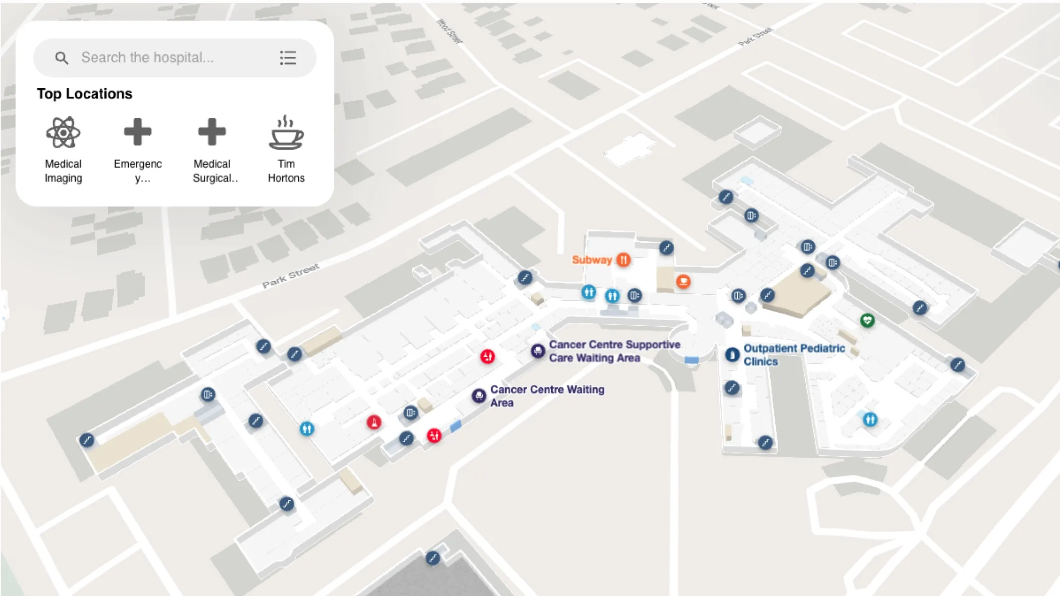
Hospital wayfinding signage applications:
- Pre-visit links to routes
- Accessible and step-free defaults
- Visitor and staff mode
- Clear arrival confirmations at destinations
University & college campus wayfinding signage
College and university campuses are essentially mini-cities. With sprawling footprints that often span entire towns, studies show that navigating and finding intended destinations is daunting and stressful for students and visitors.
Of those:
- 30% said it was due to a lack of a wayfinding solution
- 29% said it was due to because of insufficient signage
Multi-building campuses like these—including universities, academies and museums—need wayfinding signage that adapts to changing schedules, room assignments, and event-day traffic. Interactive directories with map layers for classes, exhibits, or gates, plus shuttle and parking integrations, help first-time and returning visitors navigate confidently across buildings and floors.
Campus wayfinding signage applications:
- Event- and schedule-aware maps
- Ingress/egress modes
- Shuttle and parking layers
- QR handoff to mobile
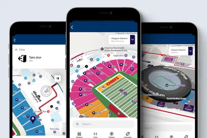
Sports stadium wayfinding signage
Imagine the last time you went to a football game or soccer match. Would you have been able to find your seat, a restroom, or food vendor without wayfinding signage? At a stadium, sports fans need seamless navigation to get to their intended destination – there’s no time for seeking out cumbersome directions from a stadium worker.
Wayfinding signage is also critical when it comes to safety and preparedness at a large venue like a stadium, offering clear and real-time route information and safety instructions.
Stadium wayfinding signage applications:
- Fast seat-finding
- Concessions and merch discovery
- Accessibility and family services
- Post-game exit routes
Planning and implementing a wayfinding signage program
Now that the value and importance of wayfinding signage is clear, it’s time to plan and implement the right signage solution. A successful program:
- Starts with clean data
- Aligns stakeholders
- Scales with repeatable governance
Treat the content model (destinations, categories, accessibility attributes) as an enterprise asset so updates flow to every touchpoint—static signs, kiosks, web, and mobile. Consistency is the backbone of effective wayfinding, and it begins with an accurate inventory and naming system.
When planning a wayfinding signage program, consider these consideration steps:
1. Audit and data gathering
Begin by cataloging all points of interest (POIs), amenities, entrances, and decision points, and standardize names, abbreviations, and categories to eliminate ambiguity.
Capture floor plans, level connections, and path networks, including accessibility constraints (e.g., step-free routes, door clearances), so the digital model reflects reality. Early coordination between facilities, operations, and customer experience teams reduces costly rework later.
2. Information architecture and map model
Design a simple, scalable information architecture with levels, zones, landmarks, and route rules (public vs. staff-only, accessible paths).
Anchor your model with recognizable landmarks and decision points. Kevin Lynch, American urban planner and author, found that legibility (the ease with which a spacial structure can be understood and navigated) improves when environments emphasize paths, edges, districts, nodes, and landmarks.
Maintain a single source of truth for locations and paths so every channel renders the same, trusted guidance.
3. Hardware selection and infrastructure
Choose screen sizes, brightness, and anti-glare treatments appropriate for viewing distance and ambient light, and ensure placements meet accessibility reach ranges and clear floor space requirements.
Specify durable kiosks, mounts, and enclosures for cleaning and high traffic, and plan power, network, and remote device management from day one. Reliable connectivity and proactive monitoring minimize downtime and support rapid content updates during disruptions.
4. Software and CMS requirements
Use a centralized CMS to manage maps, content, localization, and scheduling across venues, with roles, workflows, and audit trails for governance.
Ensure digital interfaces meet WCAG 2.1 for contrast, touch targets, and keyboard navigation, and expose APIs/SDKs to integrate data feeds like tenants, events, emergency alerts, or FIDS where applicable. Analytics for search, route starts/completions, and zero-result queries promote continuous optimization.
Measuring ROI and success
Measuring success of your wayfinding signage is an often dismissed yet critical step in an optimized program. Outline the metrics you will measure success against before the work begins, making sure to include the cross-functional working group in the decision.
Consider these metrics to prove impact or areas of improvement:
Core wayfinding KPIs:
- Search success rate and zero-result queries
- Route starts and completions
- Anecdotal staff feedback – i.e., “Where is…?” questions
Visitor engagement and monetization KPIs:
- Dwell time on directories and screens
- Click-through rate from promos and ads
- DOOH metrics
Operational KPIs:
- Number of support tickets
- Line/queue length at information or customer service desks
- Traveler on-time performance
- Patient/Visitor/Shopper satisfaction
How to evaluate wayfinding signage companies
The landscape of wayfinding signage companies spans hardware manufacturers, software platforms for indoor mapping and routing, digital signage CMS providers, and systems integrators that stitch solutions together.
Selecting the right partner starts with clarifying your use cases,—i.e, public wayfinding, FIDS-enabled travel, and healthcare routing—scale, and non‑negotiables like accessibility, security, and data ownership.
Here, we’ll show you how to prioritize wayfinding signage vendors that can prove measurable outcomes, not just features, and insist on a low-risk pilot to validate UX, integrations, and operations before broad rollout.
Vendor types
Vendors in the market span across the entire matrix of wayfinding solutions, from hardware to software to integrators and AVI partners.
Hardware providers focus on displays, kiosks, mounts, and device management, offering commercial-grade durability, service contracts, and peripherals such as printers, scanners, or accessibility buttons. They are essential for physical reliability and hygiene but typically rely on partners for mapping, routing, and content logic.
Software platforms specializing in indoor mapping and wayfinding provide the digital foundation—map data models, routing engines, SDKs/APIs, and interactive directory UX—plus governance at portfolio scale.
Digital signage CMS vendors excel at scheduling, targeting, and asset management across networks of screens; many integrate with wayfinding engines rather than building routing themselves. Some digital signage software vendors – like Mappedin – also include a CMS solution.
Systems integrators and AV partners coordinate deployment, networking, security hardening, and multi-vendor contracts, making them valuable for complex venues like airports, hospitals, and campuses where FIDS, EMR, or facilities systems must tie in.
Capabilities checklist
Reference this checklist when evaluating wayfinding signage vendors:
- Accurate indoor maps with multi-level routing, landmarks, and clearly modeled paths (public vs. staff-only, accessible).
- Accessibility by default (ADA-informed physical guidance; WCAG 2.1 AA for digital)
- Interactive directories
- Robust CMS
- Open SDKs/APIs and data integrations (tenant/event feeds, FIDS, GTFS/transit, headless CMS, emergency alerts).
- Analytics & reporting
- Reliability and performance
- Security and compliance (SSO/SAML, SOC 2/ISO 27001 alignment, GDPR/CCPA readiness)
- Content targeting and scheduling
- Data portability and ownership
Deployment and support
Look for a vendor with a proven implementation methodology: discovery and data audit, pilot, phased rollout, and post‑launch optimization.
Strong partners offer training for content and facilities teams, clear documentation, and ongoing change management so updates flow smoothly across signage, kiosks, web, and mobile.
Ask about monitoring and support coverage—24/7 availability for critical locations, response and resolution SLAs, and proactive alerts for device or content failures. For regulated environments, verify security reviews, pen tests, and accessibility testing are built into deployment, not bolted on at the end.
Mappedin, for example, is a fully packaged solution that can be easily embedded into a website to provide ongoing access to the Mappedin platform. It will be automatically updated as Mappedin evolves and improves with new features and data-driven learnings.
Mappedin: Your partner in wayfinding & signage solutions
Mappedin is the leading provider of indoor mapping solutions for complex indoor places, like airports, malls, hospitals, stadiums and more. Mappedin’s solutions are trusted by partners around the world, powering indoor maps, interactive directories, and digital signage for single-building venues to global portfolios.
Consider Mappedin as your wayfinding signage partner to get:
- Interactive directories: Search by name or category, “you are here” orientation, accessible routing, QR handoff to mobile.
- Indoor mapping platform and CMS: Centralized data management, multi-venue controls, localization, and governance.
- Integrations: Connect to data sources like tenant and event feeds and, where appropriate, flight information display systems (FIDS) to power live routing.
- Monetization: Promote offers and campaigns within the directory experience; measure engagement and optimize.
- Proven outcomes: Faster navigation, fewer staff interruptions, better visitor satisfaction, and new revenue opportunities via DOOH.
— Sharon Hislop-Holt, Manager, Commercial Business Development & Marketing, MBJ Airports Limited

Wayfinding signage FAQs
What is wayfinding signage?
Wayfinding signage guides people through environments using identification, directional, informational, and regulatory cues. Today, it combines static signs with digital directories, interactive maps, and mobile routing.
What are the main types of wayfinding signage?
Identification (room/gate/store labels), directional (arrows and destinations), informational (hours, amenities), and regulatory (safety/compliance). Digital directories and indoor maps enhance each type with interactivity and real-time data.
What is interior wayfinding?
Interior wayfinding focuses on navigation within buildings and campuses. It emphasizes consistent naming, multi-level routing, clear decision points, and accessibility-first design.
How can digital signage enhance wayfinding?
Digital signage adds search, step-by-step routing, real-time updates, and analytics. It enables mobile handoff via QR codes and can generate revenue through context-aware promotions.
What is a flight information display system (FIDS)?
A FIDS displays live flight data—arrivals, departures, gates, and delays. Integrated with wayfinding signage, it enables passengers to go from flight lookup to gate routing and re-routes automatically on gate changes.
How do I choose among wayfinding signage companies?
Assess mapping quality, directory UX, accessibility routing, CMS strength, integrations (e.g., FIDS), analytics, deployment track record, support SLAs, security posture, and total cost of ownership. Consider a vendor like Mappedin, with proven expertise in powering indoor maps, wayfinding, directories, advertising, and signage solutions for small buildings to global portfolios.
How do I measure success of wayfinding signage?
Track search success, route starts/completions, time saved, reductions in staff wayfinding requests, engagement with promotions, and, for airports, improvements in on-time performance.
What accessibility standards should I consider?
Use ADA-informed signage for physical elements and WCAG guidance for digital interfaces. Provide high contrast, readable typography, tactile components where required, and accessible routing options by default.
Getting started
Here at Mappedin, we partner with leading global companies to deliver easy-to-use indoor mapping solutions.
Interested in seeing a demo personalized for your needs? Contact us today to get started, or check out our map gallery to see what’s possible.
Tagged In
Share